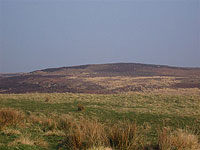
Stanbury Hill from the south
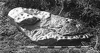
Example of prehistoric rock art
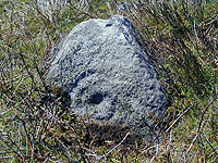
Example of prehistoric rock art
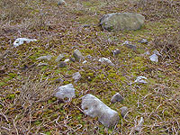
One of at least 6 cairns on Stanbury Hill
The Stanbury Hill Project:
Archaeological investigation of a rock art site
Located on the edge of Bingley Moor overlooking Bingley and the Aire Valley, Stanbury Hill is a distinct feature, a broad gentle sweep of dry higher ground overlooking Fenny Shaw Beck to the north and the slack of White Flush to the south: an ideal place for prehistoric settlement with broad commanding views all round and streams providing a supply of fresh water to both sides.
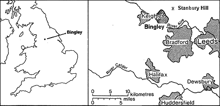
Location of Stanbury Hill, Bingley Moor, West Yorkshire
On this small hill less than 0.25km2 in area are no less than 22 separate archaeological sites or features: beginning with 18 examples of prehistoric rock art believed to date from either the Late Neolithic/Early Bronze Age, at least 6 possible Early Bronze Age ‘burial cairns’, several lines of possible prehistoric walling, as well as the find-spots for Late Neolithic flint tools – all dating from 2,500-2,000 B.C.
The site is therefore interesting for a number of reasons: the concentration of rock art, the fact that additional material such as flint tools have been recovered, the existence of other prehistoric features and most excitingly, the fact that the site was previously unrecognized and thus is still relatively intact.
The Stanbury Hill Project, a collaboration between Bingley & District Local History Society and the Department of Archaeological Sciences at the University of Bradford, aims to engage local people in their past by allowing them to participate directly in the project, to gain skills in archaeological investigation and develop a sense of ownership of their heritage. To do this the members of the society and other volunteers, supervised by archaeological staff from the University of Bradford, will:
- carry out topographic surveys
- carry out a photographic survey of the rock art and other features
- carry out geophysical surveys of the hill and its surroundings
- excavate at least one of the rock art panels
- excavate at least one of the possible cairns
- excavate some of the other features
- help with post-excavation recording and analysis
- disseminate results via exhibitions, talks and publications
- involve local societies and schools
Fiona Spiers, Head of the Heritage Lottery Fund, Yorkshire and Humber said, “This is a fantastic project which will explore the Late Neolithic/Early Bronze Age landscape of Bingley. It will enable members of the local community to learn new skills and enhance their knowledge and sense of their local heritage.”
Phases of work
In common with most archaeological projects, the work at Stanbury Hill will be in five distinct phases: desk-based assessment, fieldwork, excavation, post-excavation conservation and analysis, and finally recording and publication. Desk-based assessment has so far involved establishing the geological, agricultural and economic history of the area, checking existing and past maps, checking the archaeological literature, and consulting the West Yorkshire Archaeology Services Historic Environment Record in Wakefield as well as other local, regional and national archives.
The fieldwork will be undertaken in phases with the first concentrating on topographic, photographic and geophysical surveys: information which will contribute to the outline excavation strategy. The project will be officially launched at a public meeting to be held at the Eldwick Village Memorial Hall on Saturday, 20th September, from 10.30-12.00. Work will begin during the late summer of 2008 and the post-excavation archive work completed before the end of March 2009.
The work of the project is likely to be of interest to a wide range of groups: thus, a presentation will be given at the West Yorkshire’s annual Archaeology Day together with a contribution to the regional CBA group, including their annual symposium in York in February. In addition in 2009, it is planned to have site visits, an Open Day at the Department of Archaeological Sciences at the University of Bradford, talks to local groups and a travelling public exhibition based at each of the libraries and/or museums in the various towns that surround the moor. There are also plans to involve local schools in a variety of ways such as site visits, the preparation of teaching materials, project work and maybe even a competition.
Prehistoric rock art
The significance of prehistoric rock art as a significant element of the cultural heritage of Britain has only recently been acknowledged by academic archaeologists and heritage agencies. The total number of rock art sites in the UK is unknown, the majority of which are found in Southern Scotland and Northern England. At present around 2500 carved panels have been recorded in England, mostly in Northumberland, Durham and Yorkshire. Locally, the work of Dr. Keith Boughey and his colleagues in the former West Riding of Yorkshire (principally Airedale, Wharfedale, the Washburn Valley and Nidderdale) has so far identified 690 panels of rock art, many new to the archaeological record. New sites are being identified continually.
The majority of work in the past focused upon the identification, location, recording and assessment of the degradation of rock art in various parts of the British landscape. More recently there has been a change with a move to try and understand exactly what these monuments are and how they relate to a wider landscape. Whilst there is a long tradition of identifying and recording rock art, it is only fairly recently that any attempts have been made to understand it and place it within a context of what it actually meant to people. The aim of the project is to try and understand the site, what it was used for and what sort of landscape it existed in. One theory is that rock art represents a territorial marker denoting the boundary between the settled land which people inhabit and the wild beyond, that the rock art panels and cairns represent a sacred space which protects or separates the tamed and domestic from the untamed and wild, or the realm of the living from that of the ancestors.
As Dr. Keith Boughey, Director of the Project, explained:
“Stanbury Hill is a relatively undisturbed prehistoric moorland site. As such, it provides a unique opportunity for both archaeologists and the local community to learn more about their Bronze Age past, especially the rock art, as well as providing volunteers with the experience and skills of an archaeological dig at first hand, supervised by a Department of Archaeology with a first-class record.”